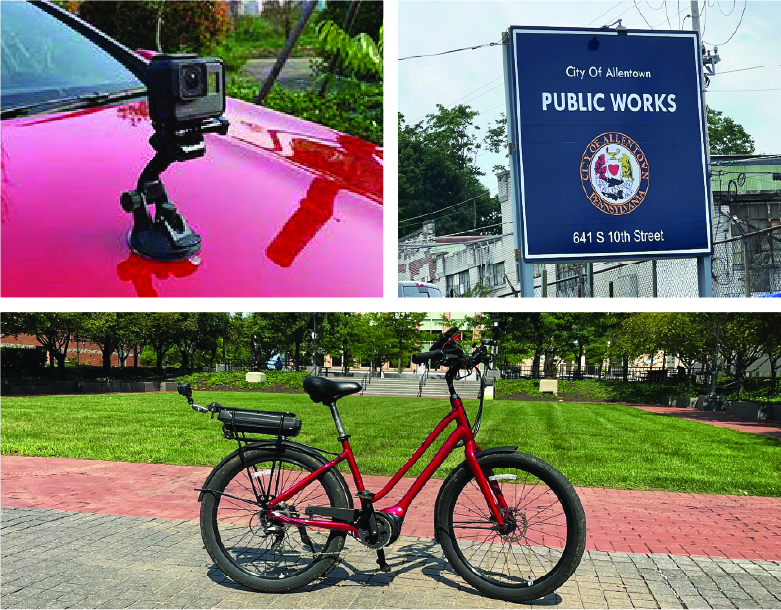
City of Allentown, Pennsylvania Sign Inventory and Condition Assessment
Scope: The City of Allentown, Pennsylvania (PA) initiated a project for a comprehensive Sign Inventory and Condition Assessment to improve asset management and enhance roadway safety.
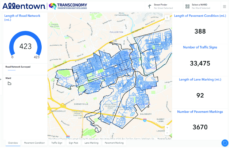
This project, covering approximately 210 centerline miles within the city’s urban road network, involved creating an inventory of roadway signs, assessing their conditions, and implementing ESRI Sign Manager to manage the sign inventory. In addition to roadway signage, the project scope included a Pavement Surface Evaluation and Rating (PASER) assessment, as well as an evaluation of pavement markings and striping to ensure overall roadway visibility and safety.
Transconomy conducted the assessment using high-resolution right-of-way imagery, processed by AI models aligned with Pennsylvania’s MUTCD standards. This approach ensured accurate data on each sign’s condition, location, and specifications, along with a thorough review of pavement and road markings to support Allentown’s comprehensive transportation asset management objectives. This data was presented in Transconomy’s proprietary viewer application as well as in an ESRI ArcGIS Dashboard. The insights enabled city planners to prioritize maintenance efforts and allocate resources effectively.
Process: The project encompassed several phases, beginning with project management to oversee scope, schedule, budget, and quality.
Transconomy’s Navigator application, designed for real-time image collection, along with GoPro off-the-shelf cameras, captured roadway images tagged with GPS data across the specified network. Of particular note, an e-bike was used to capture images of alleyways and bike paths which could not be assessed easily by car.
This imagery was processed through Transconomy’s cloud-based AI models, which detected, classified, and assessed the condition of roadway signs and the pavement. Images were quality-controlled to ensure precise asset classification, and additional training was provided for city staff to navigate Transconomy Viewer and the Dashboard to utilize this data effectively.
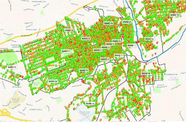
Results: Transconomy provided the city with access to visual data on sign locations, conditions, and classifications, enabling users to conduct a virtual “drive-through” of Allentown’s roadways. Deliverables were made available in multiple formats (CSV, SHP, and KML files) and accessible via Transconomy Viewer and Dashboard, which allowed for filtering and analysis of asset data, supporting Allentown’s transportation management decisions.
During the project, Transconomy identified and cataloged over 33,000 signs across the City of Allentown’s road network. Each sign was assessed for condition, classified, and geo-tagged with precise GPS coordinates, following Pennsylvania MUTCD standards (Publication 236). A PASER assessment was also conducted to gauge overall road surface conditions.
To enhance accessibility and usability of the data, a custom dashboard was developed, allowing city officials to view, analyze, and interact with the comprehensive dataset in real time. Additionally, ESRI Sign Manager was implemented to provide seamless integration of the sign data into the city’s existing GIS system, enabling efficient management, maintenance tracking, and data updates within a familiar platform.
Based on these detailed assessments, a cost analysis was conducted to estimate expenses for restoring, replacing, or maintaining signs based on their current condition ratings (good, fair, or poor). Signs that were obstructed by vegetation were also identified for maintenance actions by the city. By integrating PA MUTCD standards with remediation cost projections, a strategic framework was delivered to help Allentown prioritize maintenance and replacement. This data-driven approach enabled the city to budget effectively, address critical safety needs, support efficient resource allocation, and strengthen its long-term asset management plan.
Benefits: This project provided Allentown with actionable insights into the condition of its roadway signage and other critical assets, including pavement markings and overall pavement condition.
The deliverables encompassed a range of asset types, including sign inventory, signpost type, sidewalk inventory, driveway apron inventory, curb ramp inventory, no curb ramps on a corner inventory, curb marking inventory, line striping inventory, and pavement marking inventory, as well as an extraction of the pavement section geometry information (length, width, and area) for the pavement management sections.
Aligning the deliverables to the city’s pavement segmentation provided an integrated and current inventory and condition for these assets in conjunction with the updated PCI survey, creating valuable data inputs for planning and programming in concurrent efforts.
Benefits: NCE, as a trusted advisor to the city, enhanced the value derived from the field data
collection activities and the collected geo-coded imagery.
The City of Santa Maria leveraged its investment in a pavement condition assessment and pavement area calculation project to enhance its overall dataset by gaining inventory and condition information on nine additional right-of-way assets, adding key insights for asset management and valuation.
The asset extraction and area calculation enabled a more comprehensive understanding of the city’s transportation infrastructure. The resulting data empowered the city to support proactive maintenance, strategic planning, and data-driven decision-making—contributing to improved sustainability, better resource management, and long-term infrastructure resilience for the community.
Transconomy’s solution demonstrated an efficient, scalable, and cost-effective solution, increasing the value of the investment in field data collection activities and providing robust data enabling a more holistic perspective for
pavement and asset management.
With GIS-enabled data and an intuitive viewer application, Allentown can efficiently make data-driven decisions on resource allocation across various assets. The implementation of ESRI Sign Manager and a custom dashboard further enhances the city’s asset management capabilities, allowing city officials to manage and monitor signage, pavement condition, and markings in real time. By taking a comprehensive view of all these elements, Allentown can improve overall transportation safety, extend asset longevity, and allocate its budget more effectively to meet long-term infrastructure goals.